
Get your bearings
Find your place
by the lake.
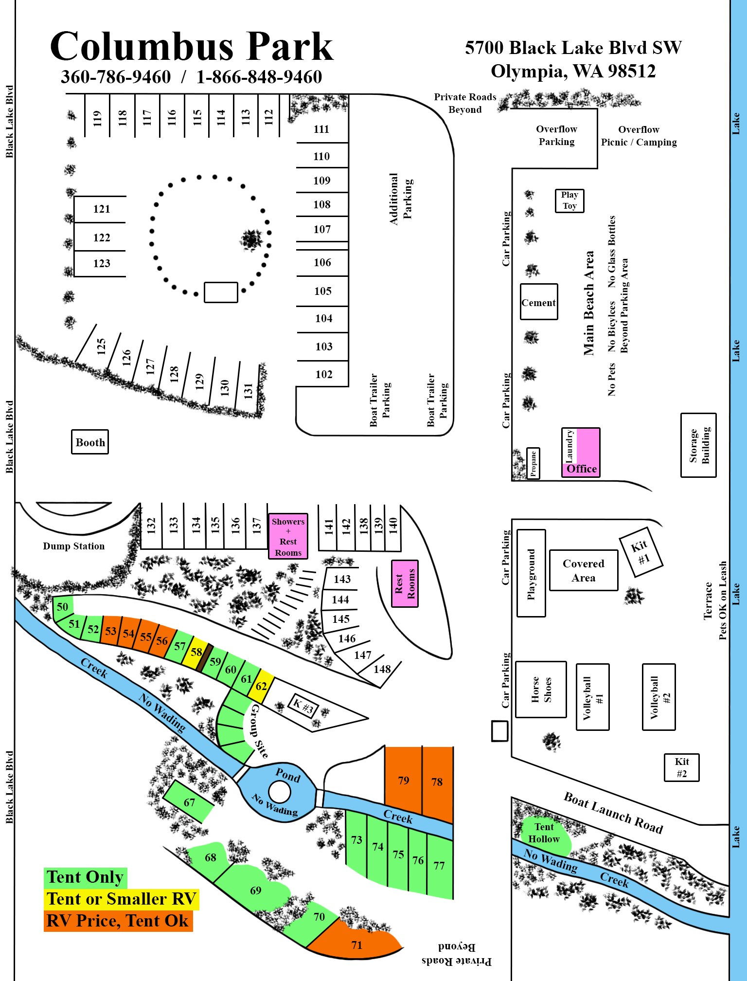
The Columbus Park map shows the park layout, from the entrance and campsites to the beach and boat launch. Open the map full size to read the smaller labels.
5700 Black Lake Blvd SW
Olympia, WA 98512
Need help choosing a site?
Share your RV length, group size and access needs with the office.
Map locations in text
This describes the park’s 2026 campground map, the one the office hands out to campers. Confirm your assigned site, current facilities and access needs with the office.
Layout and numbered sites
- Black Lake runs down the right edge of the map and Black Lake Blvd down the left. Private roads continue beyond the top and bottom of the map.
- Upper left: sites 112–119 run across the top; 121–123 sit on the left; 125–131 sit below. Sites 102–111 run down the right side of this area, beside Additional Parking and two Boat Trailer Parking areas. A booth is below site 125.
- Middle: sites 132–137, then the Showers and Rest Rooms, then sites 141, 142, 138, 139 and 140, in that order. Sites 143–148 curve below them beside a second Rest Rooms. The Dump Station is at the left, by the boulevard.
- Lower left: sites 50–62 follow the creek toward the pond, with the Group Site below sites 60–62 and the area labelled K #3 beside site 62. Site 67 is left of the pond, 68–71 run along the bottom, 73–77 sit below the creek on the right, and 78–79 sit above it.
- Right side, top to bottom: Overflow Parking and Overflow Picnic / Camping; the Main Beach Area with Play Toy and Cement (no pets, no bicycles and no glass bottles beyond the parking area); Propane, the Office and Laundry; a Storage Building; then the Playground, Covered Area, Kit #1, Horse Shoes, Volleyball #1 and #2, and Kit #2. The terrace by the lake is marked “Pets OK on Leash.” Car parking runs along the central road.
- Bottom right: Boat Launch Road runs to the lake, with Tent Hollow beside the creek below it. The creek and pond are marked “No Wading.”
Site colour legend
- Tent only (green): 50–52, 57, 59–61, the Group Site, 67–70 and 73–77, plus Tent Hollow.
- Tent or smaller RV (yellow): 58 and 62.
- RV price, tent OK (orange): 53–56, 71, 78 and 79.
- The other numbered sites (102–119, 121–123, 125–148) have no legend colour on the map. Ask the office which site fits your stay.